Overview
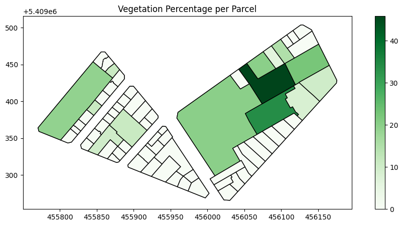
This project analyzes the proportion of green spaces within French property parcels by using cadastral data (Edigeo / DXF) and satellite imagery. Using Python, rasterio, and geopandas, we calculate parcel-by-parcel NDVI (Normalized Difference Vegetation Index) to determine the percentage of vegetation.
Key Features
Parcel Extraction
Utilizing Edigeo to produce georeferenced parcel polygons. Optionally supports DXF if CRS alignment is resolved.
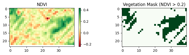
NDVI Computation
Harness near-infrared satellite imagery to compute NDVI and classify vegetation.
Parcel Masking
Use rasterio.mask to overlay each parcel polygon onto the NDVI raster, calculating green coverage.
Workflow
Convert Edigeo data to a georeferenced Shapefile or GeoPackage.
Load and reproject satellite imagery to match parcel CRS.
Calculate NDVI from Red & NIR bands.
Clip the NDVI raster by each parcel polygon to compute vegetation %.
Showcase Screenshots
Documentation & Limitations
- CRS Alignment: Edigeo data typically uses Lambert-93 (IGNF:LAMB93/EPSG:2154). Ensure the raster is reprojected accordingly.
- NDVI Thresholds: A threshold (~0.2) is used to classify vegetation. Different thresholds can yield different results.
- Seasonal Variation: NDVI depends on the time of year the imagery was captured. Cloud cover can skew results.
More Info
Interested in the full code or want to discuss a similar project? Let's connect!
Email Me